June 3

What was advertised in a colonial American newspaper 250 years ago this week?

Jun 3 - 5:31:1770 Pennsylvania Journal
Pennsylvania Journal (May 31, 1770).

“At the sign of the Jolly Sailor.”

In an era before standardized street numbers, advertisers resorted to a variety of means of describing their locations.  Consider the various directions that appeared in the May 31, 1770, edition of the Pennsylvania Gazette.  Some were brief, such as John Willday’s invitation to visit “his store in Fourth-street, near Market-street.”  Willday believed that prospective customers who could locate the intersection of Fourth and Market could then easily locate his store.  Others provided more extensive directions.  John Day and Company, for instance, sold an assortment of remedies at “their Medicinal Store, next door to Jonathan Zane’s in Second-street, between Market and Chesnut streets.”  In addition to listing the cross streets on either side of their store, Day and Company also identified a nearby landmark to aid prospective customers.  Willday also invoked a landmark in giving the location of his second location, a store “near Christiana Bridge.”  Mrs. Bussiere, who sold starch and hair powder, gave extensive directions.  She sold her wares “in Mr. Fishbourn’s house, at the corner of Walnut and Water-streets, opposite Reese Meredith’s.”

To provide further aid in finding their businesses, some advertisers displayed painted or carved signs.  A notice about an upcoming sale of lots on Noble Street advised bidders to seek “the house of Benjamin Davis, in Northern Liberties, near the new Landing Place on Front-street, at the sign of the Jolly Sailor.”  The street and a nearby landmark directed bidders to the general vicinity, but the sign marked the specific location.  Duffield and Delany, druggists, adopted a similar strategy, instructing prospective clients to find them “At Boerhaave’s Head, the Corner of Second and Walnut streets.”  A sign depicting Herman Boerhaave, the Dutch physician and botanist, helped customers identify their shop once they arrived at the intersection.  Similarly, Robert Kenneday and Thomas Kenneday sold both prints and patent medicines “At their Print Shop, at West’s Head near the Bridge, in Second-street, below Walnut street.”  The streets and a landmark directed prospective customers to their neighborhood, but the sign depicting Benjamin West “of this city, now history painter to the King” clearly identified their place of business.

These examples demonstrate that signs often did not replace the need to offer other sorts of directions, such as streets, intersections, and landmarks, yet in the absence of street numbers they provided a means of denoting a particular location.  They also served as landmarks themselves, aiding both residents and visitors in navigating the streets of bustling port cities.  Some advertisers who did not have signs of their own occasionally made reference to their location in relation to shop signs displayed by others.  The signs listed in advertisements and displayed throughout cities like Boston, Charleston, New York, and Philadelphia helped people make sense of urban geography in eighteenth-century America.

March 16

GUEST CURATOR: Daniel McDermott

What was advertised in a colonial American newspaper 250 years ago today?

Mar 16 - 3:16:1767 Newport Mercury
Newport Mercury (March 16, 1767).

“Baizes, Duffels, Shalloons, Tammies, Calimancoes.”

William Cornell placed this advertisement for the array of textiles he sold. By today’s perspective the list seems foreign. However, in colonial America any person reading this advertisement would have known each material, including what style, how expensive, and common uses.

One textile on the list that may seem unfamiliar is baize. The Oxford English Dictionary describes baize as “A coarse woollen stuff, having a long nap, now used chiefly for linings, coverings, curtains, etc., in warmer countries for articles of clothing.” The OED also states it was used for shirts and petticoats. Abigail Adams wrote a letter to her husband, John Adams, and refered to a “Green Baize Gown,” making a recommendation to keep him warm during the cold nights: “I would recommend to you the Green Baize Gown, and if that will not answer, You recollect the Bear Skin.” This suggests baize could be heavy enough to be used for warmth during cold winter nights, just as warm as a “Bear Skin.” (Today, baize is most famously used to cover pool tables.)

Tammies were another textile Cornell sold that may seem unfamiliar. According to the Dictionary of Traded Goods and Commodities, 1550-1820, tammy is a lightweight fabric, but because of its simple weaving the material is also strong. Due to its durability but light weight it was utilized for linings, children’s garments, or curtains. Tammy was also often dyed yellow, a color that quickly faded when exposed to light. Yellow tammy may have been chosen for linings that would have been less exposed and thus less likely to fade.

**********

ADDITIONAL COMMENTARY: Carl Robert Keyes

When Daniel and I met to discuss William Cornell’s advertisement, we considered several aspects to examine in greater detail. Daniel ultimately opted to investigate some of the unfamiliar textiles, but during the research and writing process he also contemplated what this advertisement told us about colonists’ understanding of urban geography and how to navigate port cities.

In an era before standardized street numbers and addresses, colonists relied on a variety of landmarks to give directions. Advertisers frequently assumed that potential customers, especially in towns and smaller cities, were familiar with both local places and people. For instance, Cornell offered nothing by way of directions except noting that his shop was “Adjoining to Captain Robert Stoddard’s.” Apparently Stoddard was sufficiently known among residents of the port city that Cornell considered this sufficient for directing potential customers to his own business.

Some advertisers relied on their names alone, neglecting to offer any other sort of directions. Such was the case for Samuel Sanford (who advertised “A few Puncheons of Jamaica Rum”), Gideon Wanton, Jr. (who carried “Ticklenburgs [and] Osnaburgs,” textiles that did not appear in Cornell’s notice), and Joseph West (who sold “A Quantity of dry Cod Fish”).

Others provided a street name, a landmark, or a combination of the two to aid potential customers in locating them. John Hadwen, for instance, peddled his wares “At his Shop in Thames Street,” while Napthali Hart, Jr. sold a similar array of goods “At his Store on Mr. GEORGE GIBBS’s Wharf.” George Cornell maintained “Batchelor’s Hall,” presumably a boardinghouse, “IN Mill-Street, near the Ferry Wharf.”

Two other advertisers offered more complex directions. Christopher Smieller, a baker, announced that he “has removed from Mr. William Gyles’s Bakehouse, to that of Mr. Joseph Tillinghast.” Francis Skinner, a bookbinder, provided the most complicated – or perhaps the most exact – set of directions. Customers could find him “at his House the third below Trinity Church, on the East Side of the Street leading to the Neck.”

Regardless of how many or how few words any of these advertisers used, each expected readers and potential customers could make their way to their respective businesses based on the information they provided. Even the largest American cities were not yet so large in the 1760s to necessitate street numbers and standardized addresses to facilitate commerce. That changed by the end of the eighteenth century: advertisements increasingly included street numbers and a new kind of publication, the city directory, listed standardized addresses for residences and businesses alike. Both innovations transformed how early Americans, both locals and visitors, thought about navigating city streets.

January 18

What was advertised in a colonial American newspaper 250 years ago this week?

jan-18-1171767-providence-gazette
Providence Gazette (January 17, 1767).

A Quantity of good Cheese, to be sold … ON the West Side of the Great Bridge.”

When Caleb Harris announced that he sold a “Quantity of good Cheese … ON the West Side of the Great Bridge, in Providence,” he invoked a landmark familiar to residents of the town, one that other advertisers in the Providence Gazette frequently used to direct potential customers to their businesses as well. In the same issue, for instance, Thompson and Arnold advertised “their Shop near the Great Bridge, in Providence.” Where was the Great Bridge?

Rhode Island Currency provides a brief history of the Great Bridge, as well as images of Great-Bridge Lottery Tickets printed and distributed in October 1790. The Great Bridge connected the confluence of Westminster and Weybosset Streets to Market Square. (See a map drawn in 1790 by a student at the College of Rhode Island, now Brown University.) A bridge had originally been constructed at that site in 1711. The first span measured only twelve feet wide, but in 1744 the Great Bridge was widened to eighteen feet. In the early 1790s the Great-Bridge Lottery funded a further expansion of the bridge to fifty-six feet. According to Welcome Arnold Greene, the “eastern abutment was extended forty feet into the river to allow room for a proposed ‘Water Street’ to pass over.”

As Providence became an even more prosperous and populated port city in the nineteenth and twentieth centuries, the crossing at the site of the original Great Bridge continued to expand. Over the years city planners joined together several bridges into a single decking that covered approximately two acres of the Providence River. In the process, the appearance of downtown Providence transformed significantly. What had originally been the modest Great Bridge of the colonial era became the 1147-feet-wide Crawford Bridge, recognized as the “widest bridge in the world” by the Guinness Book of World Records.

The Crawford Bridge no longer exists. In efforts to revitalize the downtown district in the 1990s, Providence removed the Crawford Street Bridge, uncovering the Providence River and its tributaries, the Woonasquatucket and the Moshassuck. (This allowed for creation of the popular WaterFire festival that takes place throughout the year, though mostly in warmer months, in Providence.) Half a dozen or so smaller bridges allow traffic and pedestrians to cross the river and its tributaries.

Although the Great Bridge itself no longer exists, residents and visitors to Providence experience a riverfront that today more closely resembles its appearance during the colonial era than it did throughout most of the twentieth century. Urban renewal actually returned aspects of the city to its eighteenth-century past.

October 26

GUEST CURATOR: Megan Watts

What was advertised in a colonial American newspaper 250 years ago this week?

oct-26-10251766-providence-gazette
Providence Gazette (October 25, 1766).

“Choice French Indigo.”

This advertisement only contained three items: “Choice French Indigo, the best Florence Oil, and Fyal Wine.” All three have something in common: they were exported from foreign countries. The indigo was French, the oil was Italian, and the wine was Portuguese. These products represented international trade. However, international trade meant competing suppliers.

One product that fostered competition was indigo. An important commodity, it was in high demand because it produced a specific dye. According to Kenneth H. Beeson, Jr., “Indigo was the most important vat dye used by the British in the eighteenth century.”[1] South Carolina focused on the indigo trade. Colonists there invested a significant amount of land and energy into producing indigo. The effort resulted in American indigo becoming a serious threat to foreign suppliers. As R.C. Nash notes, “Carolina indigo … succeeded in displacing French and Spanish indigo in the British and in some continental markets.”[2] The colony’s economy relied upon the value of indigo. When the indigo trade did well, South Carolina prospered.

American indigo did not, however, completely push out all other suppliers. The fact that French indigo was being advertised in a colonial newspaper is a testament to the continuing competition between different indigo suppliers. Regardless of the success of the competition, the South Carolina economy depended heavily on indigo and it played an important part in early American economics.

**********

ADDITIONAL COMMENTARY: Carl Robert Keyes

Recently several guest curators have commented on what eighteenth-century advertisements reveal about how colonists imagined urban spaces and navigated the cities where they resided or visited. In its starkness, today’s advertisement also demonstrates how much living, working, and shopping in cities has changed over the last three centuries.

This advertisement announced that readers of the Providence Gazette could purchase three popular commodities – indigo from France, olive oil from Italy, and wine from the Portuguese island of Faial in the Azores – “at the Sign of the Golden Eagle, in Providence.” Even by eighteenth-century standards this means of specifying the store’s location was quite sparse. The advertisement did not indicate the name of the seller who made these commodities available, nor did it list the street where customers could find “the Sign of the Golden Eagle.”

The advertiser apparently believed that “the Sign of the Golden Eagle” was such a well-known landmark that further directions were unnecessary. Presumably residents of Providence already knew where to find it, which suggests that the sign had been in place for quite some time. The proprietor may not have needed to include his (or possibly her) name in the advertisement because he (or she) was already so closely associated with the “Sign of the Golden Eagle” among the local populace.

In addition to giving the sign as the most significant landmark for locating the purveyor of indigo, “Florence Oil, and “Fyal Wine,” the advertisement included one piece of geographical information. The establishment could be found “in Providence.” Although neither the street nor the name of the proprietor was listed, it was necessary to specify the city or town since the Providence Gazette circulated throughout Rhode Island and beyond. Other businesses in other places had their own “Sign of the Golden Eagle.”

In modern advertisements entrepreneurs carefully specify where prospective customers can find their place of business. They list street addresses and significant landmarks. This advertiser may have been just as invested in readers knowing where to find the indigo, olive oil, and wine they needed or desired, but the nature of Providence as an urban space in 1766 required a different level of detail in providing directions for customers.

**********

[1] Kenneth H. Beeson, Jr., “Indigo Production in the Eighteenth Century,” Hispanic American Historical Review 44, no.. 2 (May 1964), 214.

[2] R.C. Nash, “South Carolina Indigo, European Textile, and the British Atlantic Economy in the Eighteenth Century,” Economic History Review 63, no. 2 (May 2010), 362.


September 7

What was advertised in a colonial newspaper 250 years ago today?

Sep 7 - 9:7:1766 Providence Gazette
Providence Gazette (September 7, 1766).

“The Business of BUTCHERING … is carried on, by BENAJAH LEWIS, and Company.”

Benajah Lewis and Company’s advertisement for “their Slaughter House … in the Main-Street PROVIDENCE” reminds us how much the spatial geography of cities has changed since the colonial era. Livestock would have been a fairly common sight in many areas of busy port cities, though cattle and hogs are absent from the urban landscape today. A slaughterhouse would have emitted both loud noises and unpleasant smells, but those have been replaced with loud noises and unpleasant smells of completely other sorts in the wake of urban development, expansion, and industrialization. Today, Armando and Sons Meat Market, Central Meat Market, Joe’s Meat Market, and Plainfield Meat Market each provide specialized butcher services and an enticing array of products to residents of Providence, but none of their websites indicate that live animals are slaughtered on site. That work seems to take place elsewhere (and may even be mandated by health codes and other regulations), distancing most carnivorous consumers from the ultimate source of their meals, much more so than colonists and the animals they ate.

As an aside, it’s interesting to note that two days ago I identified continuity between a newspaper advertisement published in 1766 and current “going out of business” promotions, but today’s advertisement included something that I sincerely doubt would be seen today. Lewis and Company ended their advertisement with a nota bene informing potential customers that “Said Lewis, keeps a good Stable, well provided, for Horses.” Given modern American sensibilities, it seems unlikely that any butchers would mention horses, even just the stabling of horses, in an advertisement promoting the meat sold at their shops or slaughterhouses. To do so would cast suspicion on the quality and the origins of the products they sell.

In Which Addresses in Adverts Reveal Changing Conceptions of Urban Landscapes in Early America

I have devoted several years to studying advertising in early America. As the project has unfolded, I have discovered that some people are drawn to certain advertisements because the addresses they include seem quaint or charming compared to modern systems of dividing up space and denoting locations. I’m content that old-fashioned addresses, those that lack a street number but instead rely on landmarks or familiarity with the surrounding area, encourage others to learn more about what the other elements of advertisements reveal about early American life and culture. However, I also try to make the case that the addresses themselves consist of more than just obligatory or introductory material to commercial notices. The addresses, in whatever form they happened to take, also reveal quite a bit about the world inhabited by eighteenth-century Americans.

Whenever possible, I have noted the location or directions provided in eighteenth-century advertisements (including “At the Sign of the Black Boy” in yesterday’s advertisement from tobacconist Augustus Deley), exploring what they tell us about early American life and culture. Some advertisements featured earlier this week also suggested the connections early Americans made among politics, commerce, and their conceptions of the spaces and places around them, including Barnabas Clarke’s shop “Near Liberty-Bridge” in Portsmouth, New Hampshire, and Adam Collson selling wool “Under the TREE of LIBERTY” in Boston. In both instances, the advertisements referenced recent protests against the Stamp Act.

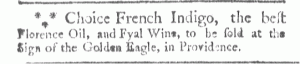
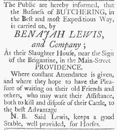
In many cases the addresses included in advertisements help to demonstrate change over time, how much our understanding of commerce and the urban landscape has changed in last quarter of a millennium. In other instances, however, the locations – especially shop signs – testify to continuity as much as change. Consumers may not look for the “Golden Key” or the “Sign of Admiral Vernon” any longer, but they do easily recognize a sign with a stylized red target or a pair of golden arches.

For the most part, modern businesses identify their location with a standardized address, even if their advertising offers additional information and directions to help potential customers find them. (Some advertising explicitly notes which standardized street address should be entered in a GPS device in order for customers to successfully navigate to their place of business.) Yet numbered street addresses do not appear in advertisements from 1766. When did this become a common practice? Once again, we have to look to the eighteenth century, though in this case the last decades of that century, to witness this innovation. Advertisements, along with other sources from the period, help us to understand how consumers reimagined urban spaces.

Under the pressure of increasing population growth, economic development, and urban expansion, residents of Philadelphia, Boston, New York, and other urban ports devised new ways of positioning themselves within the urban landscape, creating a new spatial geography that helped orient residents in these more complex commercial cities. As David M. Henkin stresses in his examination of antebellum New York, “urban texts,” including advertisements, street signs, and building numbers, became “indispensable guides” that helped residents and visitors maneuver through the city and its increasing commercial abundance. They were also “apt symbols for a new kind of public life,” marking “the streets as belonging to an inclusive and undifferentiated public of potential readers.”[1]

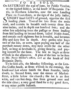
The prosaic directions listed in advertisements both registered and promoted these changes in mapping the cityscape. Let’s use Philadelphia as an example. During the first half of the eighteenth century, the city was small and easy to navigate. Colonists in 1735, for example, would have been able to purchase pickled sturgeon by following directions in a newspaper advertisement that was no more specific than “Caleb Elfreth in Third-Street.” Elfreth’s advertisement was typical of others that also appeared in the June 19, 1735, issue of the Pennsylvania Gazette. Others directed potential customers to “Mrs. Mankin” or “Miles Strickland … in Market-Street.” Some also included landmarks, including an advertisement for soap available at the “New Printing Office” and Theophilus Grew’s school “Over-against the Post-Office in Second-Street.” One advertiser made reference to a shop sign, “the Crooked Billet in Front-Street.” The city was compact enough and its population small enough that potential customers could find commercial places and people with minimal and unstandardized directions, using qualitative visual markers.

Time ran out on these older ways of marking the urban landscape during the second half of the century. Philadelphians were still likely to know the retailers who lived and worked in their neighborhoods and sometimes the locations of businesses elsewhere, especially when they had operated in the same spot for a number of years. But potential customers could no longer be counted on to know the whereabouts of most businesses, both because there were many more new commercial places and because a higher proportion of the city’s residents were newcomers. Accordingly, directions in advertisements became more specific and uniform. By the 1780s and 1790s, advertisers began to list locations that included “on the corner of Market and Third Streets,” “Front, between Arch and Race Streets,” and “Chesnut, the third door above Front street.” These were the locations or directions provided by W. Coulthard, Rundle and Murgatroyd, and Robert Smock, respectively, all in the July 5, 1790, issue of the Pennsylvania Packet. By this time other advertisers used numbered street addresses, both in newspapers and on other advertising media. For instance, James and Henry Reynolds listed their address as “56 Market Street” on their furniture label.[2] Apothecary Townsend Speakman’s billhead included “4 Second Street” as his address.[3]

Although some advertisers continued to rely on older ways of signaling location, including references to landmarks and the like, these began to look decidedly old-fashioned by the 1780s and, especially, the 1790s in the wake of city directories that listed a numbered street address for all residences and businesses. Some advertisers did incorporate traditional means of giving directions with newer forms, as did Thomas Dobson, a bookseller and stationer at “the New STONE HOUSE in Second street below Market street the seventh door above Chesnut Street” on his billhead in 1789.[4] Some advertisers also continued to refer to their shop signs, but this became less a way to signal location than one among several ways of branding their wares and their businesses. All in all, the newer directions that appeared in advertisements (in newspapers and other media) helped to disseminate a more standardized way of imagining the city spatially in the last decades of the century.

**********

[1] David M. Henkin, City Reading: Written Word and Public Spaces in Antebellum New York (New York: Columbia University Press, 1998), x, 40.

[2] James and Henry Reynolds’ furniture label, Decorative Arts Photograph Collection, Winterthur Library.

[3] Townsend Speakman’s billhead, “Bot. of Townsend Speakman” (Philadelphia: 1789), Stauffer Collection, Historical Society of Pennsylvania.

[4] Thomas Dobson’s billhead, “Bot. of Thomas Dobson,” (Philadelphia: 1789), Levi Hollingsworth Receipted Bills, Society Small Collection, Historical Society of Pennsylvania.