October 24

What was advertised in a revolutionary American newspaper 250 years ago today?

Continental Journal (October 24, 1776).

“Low’s Almanack for 1777, Being the first of American Independence.”

As they had often done before the Revolutionary War, Thomas and John Fleet and John Gill once again collaborated on printing, advertising, and selling an almanac in the fall of 1777.  The October 24, 1776, edition of Gills newspaper, the Continental Journal, carried an advertisement that announced that “Low’s Almanack for 1777” would be published and available for sale on the following Monday.  It was one of the first advertisements for an almanac published anywhere in the new nation that included a list of the contents to entice prospective customers.  The material that the Fleets and Gill included in their new almanac and in the advertisement resonated with the revolution that readers were experiencing.

To start, the printers promoted “Low’s Almanack for 1777, Being the first of American Independence.”  During the colonial era, the year had often been paired with the number of years the monarch had reigned.  Rather than set that practice aside, the Fleets and Gill adapted it to reflect the founding of the nation.  They also asserted that the contents included “every Thing necessary for an Almanack: together with a neat Plan comprehending a View of the present Seat of War at and New-York.”  Less than two months after British forces occupied New York, this almanac came with a print that depicted “General Washington’s Lines – Fort at Powles’s Hook – Bunker-Hill near the City – King’s Bridge – Hell-Gate – Fort Constitution – Mount Washington – Governor’s Island – and part of Long Island, Staten Island and the Jersies.”  Such an image would have been helpful for readers in understanding recent events.  It was also part of the commodification of people and events connected to the American Revolution that had begun during the imperial crisis.  Even before the war, printers, booksellers, artists produced, marketed, and sold a variety of prints, pamphlets, and other items that celebrated political leaders who supported the American cause, such as William Pitt and Samuel Adams, or commemorated events like the Boston Massacre.  In addition, the advertisement listed other contents of the almanac, including short essays on “Rules and Reflections for the Conduct of Life, “How to get Riches,” and “an Address to the Tories.”  A good dose of politics and current events accompanied the practical information in the almanac.  The Fleets and Gill believed that bonus material would help sell “Low’s Almanack for 1777, Being the first of American Independence.”
July 16

What was advertised in a revolutionary American newspaper 250 years ago today?

Dunlap’s Maryland Gazette (July 16, 1776).

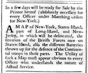
“The Utility of such a Map must appear obvious to every Officer who understands the nature of Actual Service.”

On July 9, 1776, Dunlap’s Maryland Gazette became the first newspaper outside of Philadelphia to publish the Declaration of Independence.  A week later, its first advertisement promoted a map that the printer considered essential for officers now that the aims of the war had shifted from achieving a redress of grievances to achieving independence from Great Britain.

An introduction that indicated a “MAP of New-York, Staten Island, part of Long-Island, and New-Jersey” would be ready for sale in a few days emphasized that the map was “absolutely necessary for every Officer under Marching orders for New-York.”  As they gathered equipment and supplies in advance of departing to defend New York, officers needed to outfit themselves with a map that “delineated, the situation of the British Forces now on Staten-Island” as well as the “different Batteries thrown up for the defence of the Continental troops in those parts.”  Just in case the target audience had not grasped the appeal made in the introduction, the advertisement concluded with an assertion that the “Utility of such a Map must appear obvious to every Officer who understand the nature of Actual Service.”  Not purchasing the map, the advertisement suggested, amounted to a dereliction of duty.

The advertisement, without revision, ran for two more weeks, promising the imminent publication of the map even after the time that it “will be ready for Sale” based on when the notice first appeared in the newspaper.  The printer did not follow up with another advertisement announcing the publication and availability of the map.  Was that because he did not consider such an advertisement necessary … or because plans for publishing the map did not work out?  I cannot find an extant copy of the map described in the advertisement, but copies of a map with a similar (but much lengthier) title are in the collections of several historical societies and research libraries: A Plan of New York Island, with part of Long Island, Staten Island & East New Jersey, with a Particular Description of the Engagement of the Woody Heights of Long Island, between Flatbush and Brooklyn, on the 27th of August 1776 between Hist Majesty’s Forces Commanded by General Howe and the Americans under Major General Putnam, Shewing also the Landing of the British Army on New-York Island, and the Taking of the City of New-York &c. on the 15th of September Following, with the Subsequent Disposition of Both the Armies.  William Faden published that map in London.  It certainly was not the map from the advertisements in Dunlap’s Maryland Gazette in July 1776 … yet the possibility exists that the engraver consulted (and updated) an American map that depicted the same area when creating the map of those historic battles.